BY QUINT QUALLS
While Spring Hill’s leaders hope to widen the city’s two-mile stretch of U.S. Highway 31 to five lanes as soon as possible, their counterparts at the Town of Thompson’s Station have different plans for their part of the major north-south corridor.
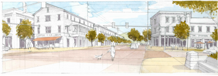
Although the widening of Highway 31 all the way from Franklin into Spring Hill is included in the state’s 2040 plan, the Town of Thompson’s Station has plans to create a new downtown area near the intersection of Highway 31 and Thompson’s Station Road.
Thompson’s Station officials conducted a lengthy process of planning and engaging residents throughout 2015 that culminated in the town’s adoption of a new Land Development Ordinance, its “blueprint for growth.”
“What came out of that vision process was pushing the city center area, the current downtown area, from the caboose and train depot and to push that downtown out to Highway 31,” said Thompson’s Station Mayor Corey Napier. “Really it would define two downtowns – one is the more historic and the other is the greater downtown area.
“It’s really analogous to what Spring Hill is trying to do out at the Tennessee Children’s Home property. We want people to slow down, pull over, get a coffee, get an ice cream cone, and all that is envisioned in that part of Highway 31. And so what I jokingly said to the folks at Spring Hill is, ‘I know the elephant in the room is 31 and if we’re going to widen it. No, we’re actually going to slow it down.’”
Town officials emphasize alternatives to road widenings
Napier said Thompson’s Station’s focus is going to be on multi-modal transportation, or alternative transportation options like walking and biking, rather than increasing the number of lanes on roads. Through the town’s new Land Development Ordinance, officials hope to maintain Thompson’s Station’s rural, agricultural identity while still growing.
“How do we create a walkable community? If you think about Highway 31, from 840 through Thompson’s Station it’s largely still green space,” Napier said. “It’s still farmland, large lot homes. We were able to work with certain property owners for easements for bikeways and greenways. That corridor in Thompson’s Station is a multi-modal opportunity. Why can’t you ride a bike from Tollgate and come to Thompson’s Station’s historic area, or conversely take a park trail. We’re thinking differently.
“It’s a state road, but TDOT is after a lot of the same things we’re after in future community planning. It’s not all about 5-6 lane cross sections. It’s about figuring out alternatives and putting density where it belongs.”
Even more important than a widening of Highway 31 to the area’s current traffic issues, according to Napier, is access to Interstate 65. Recently, a new mixed-use development of residential and commercial office space was proposed off of Buckner Lane, which incorporates a new interchange.
Like with subdivisions, where planners try to avoid only having one way in and one way out, Napier said the same principal applies from a regional outlook.
New Land Development Ordinance established plans for downtown
The Thompson’s Station Board of Mayor and Alderman formally adopted its new Land Development Ordinance on Sept. 29, 2015 after a seven-month process.
The document includes an updated sector map, which establishes the overall framework for growth in different areas of the town. In it, the area around the town’s historic area and the intersection of Thompson’s Station Road and Highway 31 is designated as a G3 Targeted Growth Sector.
According to the document, the G3 sector is intended to protect the character of the historic buildings and to intensify the intersection to create a downtown.
Quint Qualls covers Spring Hill for Home Page Media Group. Reach him at [email protected].
[scroller style=”sc1″ title=”Spring Hill News” display=”cats” cats=”75″ number_of_posts=”4″ speed=”300″]
Please join our FREE Newsletter


