UPDATE: Thursday, June 3
from NWS
A few severe storms possible Thursday
• Damaging wind gusts and hail are the main concerns
• Local brief, heavy downpours
• Late morning and early afternoon main severe risk
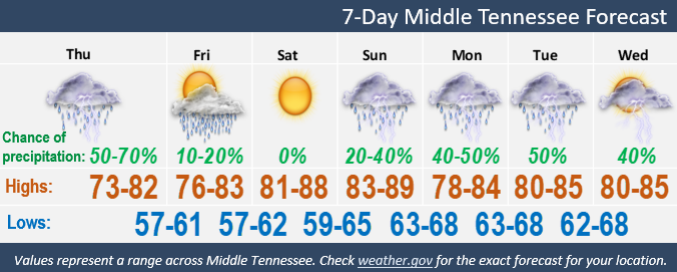
• Warm weekend ahead with highs in the 80s
• Mainly dry weekend except few showers Friday Upper Cumberland and slight chance showers/storms area wide late Sunday
 Original Story: Wednesday, June 2
Stormy weather is expected to continue Wednesday night and Thursday; however, the rain is expected to subside by Friday and the sun will come out Friday and Saturday.
A few strong to briefly severe storms are possible Wednesday evening and Thursday, reports NWS. Damaging winds will be the main threat, but a brief tornado cannot be ruled out.
A few heavy downpours will occur, mainly along and west of I-65.
NWS Daily Forecast
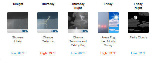 Wednesday Night
Showers and possibly a thunderstorm after 10pm.
Mostly cloudy, with a low around 64.
South wind 5 to 15 mph, with gusts as high as 20 mph.
Chance of precipitation is 70%.
New rainfall amounts between a quarter and half of an inch possible.
Thursday
50% chance of showers and thunderstorms.
Mostly cloudy, with a high near 79.
South wind around 10 mph becoming west in the afternoon.
New rainfall amounts between a tenth and quarter of an inch, except higher amounts possible in thunderstorms.
Thursday Night
30% chance of showers and thunderstorms, mainly before 9pm.
Patchy fog after 1am. Otherwise, mostly cloudy, with a low around 60.
West wind around 5 mph becoming calm in the evening.
Friday
Areas of fog before 7am. Otherwise, mostly sunny, with a high near 83.
Calm wind becoming northwest around 5 mph.
Friday Night
Partly cloudy, with a low around 62. North wind around 5 mph becoming calm.
Please join our FREE Newsletter