
After a night of snow, sleet and freezing rain Sunday, which left many roads treacherous today, here’s what to expect for the rest of Monday and Tuesday, from the National Weather Service.
The Highlights:
- More snow, sleet and freezing rain is expected
- Travel is going to be difficult and scattered power outages are possible.
- There is a broad range of temperatures and forecast snow amounts across Middle Tennessee. Some won’t see much. Some will see a lot.
- Temperatures will plummet overnight into the teens and single digits
- Any melting that occurs during the day will freeze solid overnight.
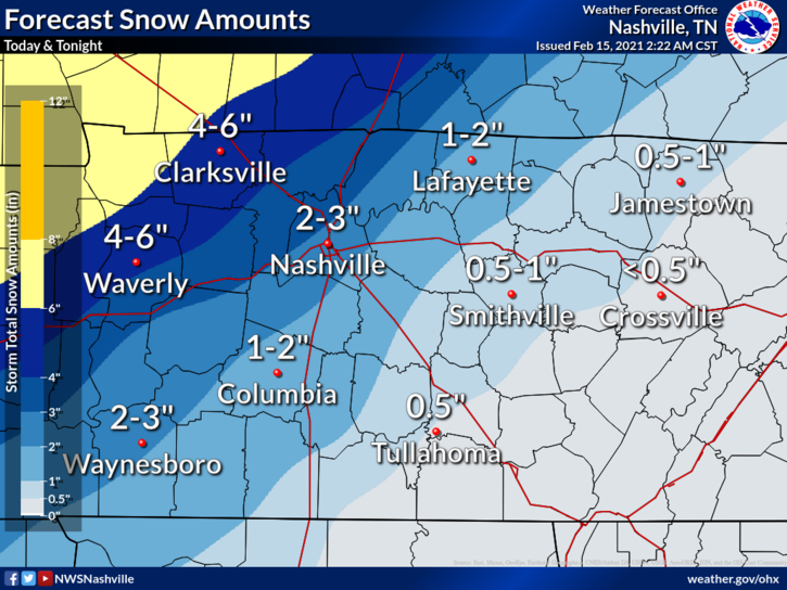
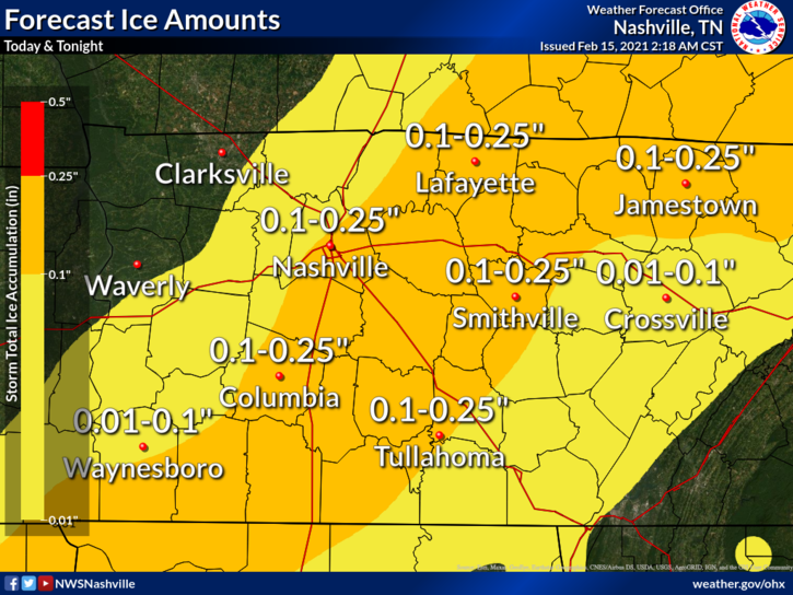
Forecasted Snow and Ice Totals:
Daily Forecast
Monday, Feb 15
- Freezing rain and sleet before 4pm, then snow.
- High near 25.
- North wind 10 to 15 mph, with gusts as high as 20 mph.
- Chance of precipitation is 100%.
- Total daytime ice accumulation of 0.1 to 0.2 of an inch possible.
- Total daytime snow and sleet accumulation of 1 to 3 inches possible.
Tonight:
- Snow, mainly before 8pm.
- Low around 11.
- Wind chill values as low as zero.
- West northwest wind around 10 mph.
- Chance of precipitation is 80%.
- New snow accumulation of less than a half inch possible.
Tuesday, Feb 16
- A chance of flurries before noon.
- Cloudy, with a high near 23.
- Wind chill values as low as zero.
- West northwest wind 5 to 10 mph.
Tuesday Night:
- Mostly cloudy, with a low around 13.
- North northeast wind around 5 mph.
Send us your snow and ice pictures at [email protected].
Please join our FREE Newsletter


")


