
Thursday’s storms brought tornado watches and warnings, hail, damaging winds, flash flooding and lots of rain to the middle Tennessee area. While that weather event has ended, more storms are predicted for Saturday (NWS predicts they won’t be as strong as Thursday’s storms). Read More Here: Storms Rolling in This Weekend
*****
Original Story from Thursday, March 25
UPDATE: March 25, 9:06pm
Nashville Severe Wx reports that the tornado warning for SE Williamson County is officially over.
UPDATE: March 25, 8:52pm
Rotation has moved out of Williamson County and is now in Rutherford County.
SE Will Co rotation has moved out of Will Co and is now in @RuthSevereWx land. / 847 PM pic.twitter.com/y5ZCNlNASa
— NashSevereWx (@NashSevereWx) March 26, 2021
UPDATE: March 25, 8:48pm
Tornado Warning continues for Chapel Hill TN, Eagleville TN, College Grove TN until 9:00 PM CDT pic.twitter.com/Xw0v15VJrg
— NWS Nashville (@NWSNashville) March 26, 2021
UPDATE: March 25, 8:39pm
A TORNADO WARNING is in effect for northeast Maury, southern Williamson, southwest Rutherford and northern Marshall Counties until 9:00 PM. This tornado is radar indicated with rotation quickly approaching Holts Corner, Chapel Hill and Eagleville. If you live in these areas take shelter now.
This does NOT include Columbia or Spring Hill. The storm has moved east of there.
UPDATE: March 25, 8:30pm
Tornado Warning officially canceled for Davidson County and Williamson County.
Also, the tornado threat in Rutherford County has passed to the east of La Vergne and Smyrna. Residents in these areas are no longer under a tornado threat. Radar continues to indicate that a tornado could develop any time near the Speedway. If you live east of this area in southern Wilson County, take shelter immediately!
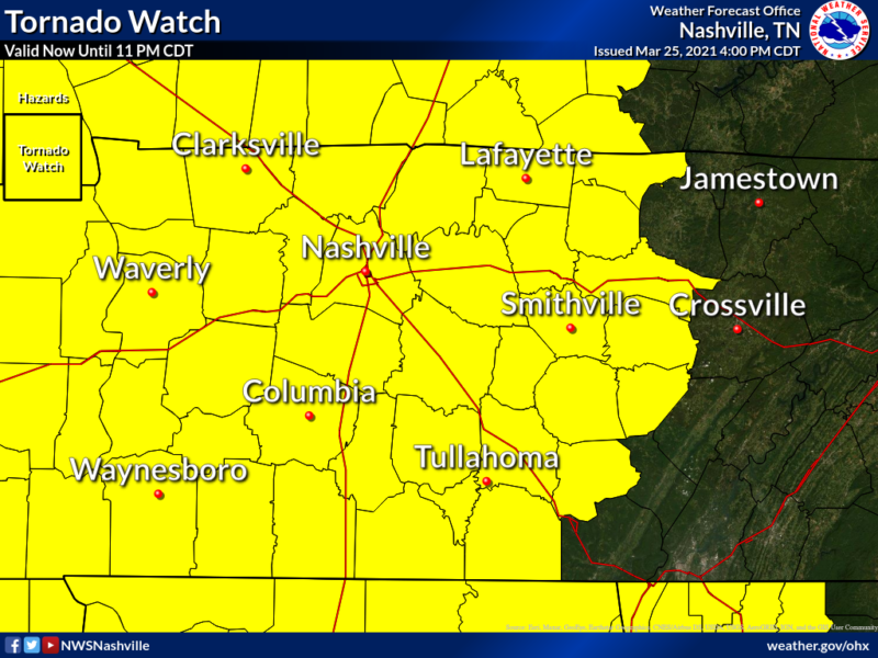
A Tornado Watch remains in effect until 1100 PM CDT for Middle Tennessee.
UPDATE: March 25, 8:22pm
Severe weather has moved into Rutherford County.
Smryna, La Vergne, Rural Hill, Gladeville… seek shelter now! There is a dangerous storm indicating rotation heading your way!
Know someone in the area? Make sure they know they are under a warning! https://t.co/eE30bDB0Ej
— NWS Nashville (@NWSNashville) March 26, 2021
UPDATE: March 25, 8:09pm
Severe Thunderstorm Warning continues for Brentwood TN, Nolensville TN until 8:30 PM CDT pic.twitter.com/777qoJ0veP
— NWS Nashville (@NWSNashville) March 26, 2021
Regarding the confirmed tornado in Waynesboro: The rotation on this storm has weakened and there have been no additional reports of a tornado on the ground since this post was written. A tornado warning remains in effect for Lewis and southwest Maury Counties until 8:15 PM. At this time, NWS does not plan on extending this warning into Columbia.
UPDATE: March 25, 7:55pm
NWS has issued severe Thunderstorm Warning for Southern Davidson County in Middle
and Williamson County until 8:30pm.
At 7:51 PM, a severe thunderstorm was located near Franklin, moving northeast at 55 mph.
60 mph wind gusts. Expect damage to roofs, siding, and trees.
Locations impacted include:
Franklin, Brentwood, La Vergne, Nolensville, Forest Hills, Oak Hill, Thompson`s Station, Antioch, Leipers Fork, Percy Priest Lake, Natchez Trace At Highway 96 and Triune.
This includes the following highways:
Interstate 65 between mile markers 57 and 77.
Interstate 24 between mile markers 55 and 63.
Interstate 840 between mile markers 19 and 43.
A Tornado Watch remains in effect until 1100 PM CDT for Middle Tennessee.
Hail pelting windows in Franklin, no indication of tornado, but straight line winds are strong. Storm moving east across 65 toward Nolensville / 757 PM
— NashSevereWx (@NashSevereWx) March 26, 2021
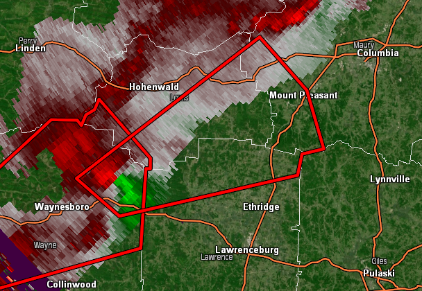
UPDATE: March 25, 7:43pm
NWS is reporting a CONFIRMED TORNADO northeast of Waynesboro, tracking into Lewis and northern Lewis Counties. Residents in these areas need to take shelter now!
This tornado warning also includes Mount Pleasant in Maury County. This does not yet include Columbia but the storm is tracking that direction. All residents of Maury County including Columbia should prepare to take shelter immediately!
UPDATE: March 25, 7:36pm
Parts of Williamson County in a severe Thunderstorm Warning until 8pm.
60 MPH winds
“Tornado possible” but it is not a tornado warned storm right now.
730 pm Forecast update. ^wm pic.twitter.com/lzeP5P6AE5
— NashSevereWx (@NashSevereWx) March 26, 2021
UPDATE: March 25, 7:11pm
Severe Thunderstorm Warning including Spring Hill, Thompson’s Station and Leipers Fork until 7:30 PM CDT. *This warning has been extended until 8pm.
This warning includes a “tornado possible” tag, meaning there is not enough evidence to issue a tornado warning, but a tornado is possible.
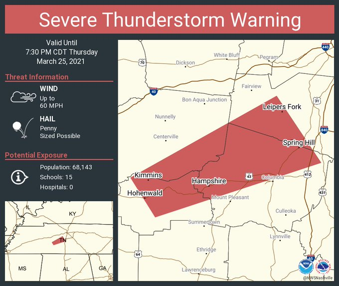
At 7:12 PM, a severe thunderstorm was located near Hohenwald, moving northeast at 75 mph.
Expect damage to roofs, siding, and trees.
Locations impacted include:
Columbia, Hohenwald, Spring Hill, Thompson`s Station, Santa Fe, Gordonsburg, Kimmins, Hampshire, Williamsport, Primm Springs and Leipers Fork.
This includes the following highways:
Interstate 65 between mile markers 49 and 52.
Interstate 840 between mile markers 12 and 26.
A Tornado Watch remains in effect until 1100 PM CDT for Middle Tennessee.
Continuous cloud to ground lightning is occurring with this storm. Move indoors immediately. Lightning is one of nature’s leading killers. Remember, if you can hear thunder, you are close enough to be struck by lightning.
UPDATE: March 25, 7pm
Signifcant Weather Advisory for Southwestern Davidson, Southeastern Dickson, Northwestern Williamson, South Central Cheatham and Central Hickman Counties until 7:30pm.
At 6L55 PM, Doppler radar was tracking a strong thunderstorm 7 miles south of Centerville, moving northeast at 65 mph.
Half-inch hail and winds in excess of 30 mph will be possible with this storm.
Locations impacted include Dickson, Centerville, White Bluff, Kingston Springs, Pegram, Burns, Fairview, Bon Aqua, Primm Springs, Lyles and Nunnelly.
This includes the following highways: Interstate 40 between mile markers 171 and 193.
Interstate 840 between mile markers 1 and 12.
A Tornado Watch remains in effect until 1100 PM CDT for Middle Tennessee.
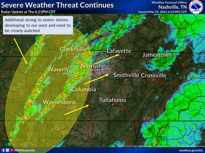
UPDATE: March 25, 6:50pm
NWS Update:
“While storms remain tame for now, our atmosphere remains very ready and prepped for severe weather. Tornado watch remains for the area until 11 PM. This includes all of Middle Tennessee. We will give the all clear when we can, but now is not the time to let our guard down. Keep those cell phones charged and have a way to receive warnings going into the evening hours.”
UPDATE: March 25, 4:30pm
Severe Thunderstorm Warning is now issued for Central Davidson County, Central Sumner County, Northeastern Williamson County and Northwestern Wilson County until 5pm.
At 4:23pm, a severe thunderstorm was located near Forest Hills, or near Franklin, moving northeast at 75 mph.
UPDATE: March 25, 4:00pm
A Tornado Watch has been issued for most of middle Tennessee (including Williamson County) from 3:45pm – 11pm on Thursday, March 25.
A Severe Thunderstorm warning has also been issued for southwestern Davidson County, northern Maury County and Williamson County until 4:30pm.
At 4:01pm, a Severe Thunderstorm was located near Columbia, moving Northeast at 80 mph
A Wind Advisory is still in effect from 4pm Thursday until 4am Friday and a Flash Flood Watch is still in effect until 1am Friday.
UPDATE: March 25, 2:25pm
NWS Update:
“The earlier showers and storms have obviously moved out of the area and we are left with some partial sunshine and relatively mild air. This is helping to destabilize the atmosphere for additional storms later on. At this time, the short-range models are showing storms moving northeastward into Middle Tennessee from northern Mississippi and Alabama after 3 p.m. and then spreading across the remainder of the mid state during the next several hours. So be on the lookout for an additional Tornado Watch for Middle Tennessee should one be forthcoming.”
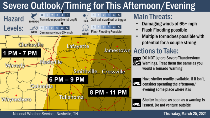
UPDATE: March 25, 12:30pm
NWS has updated the timing of the storm (see graphic below).
Again, the main threats are damaging winds, flash flooding and tornadoes.

Original Story
Severe weather, including the potential for tornadoes, golf ball-sized hail, damaging winds in excess of 60mph and flash flooding, is expected in the middle Tennessee area Thursday afternoon and evening.
Currently, a Flash Flood Watch is in effect through 1 am Friday and Wind Advisory is in effect from 4pm Thursday until 4 am Friday
Here’s What You Need to Know
*updates from NWS
- Non-severe showers and thunderstorms have already moved into southern portions of Middle TN.
- Most of middle Tennessee is in the “Moderate Risk”
- Two rounds of severe weather is expected – The first starts this afternoon around 1 pm, west of I-65. These storms could contain strong, long-track tornadoes, large hail and could produce flash flooding.
- This first round hinges on whether the rains last longer than expected. If they stick around until mid-afternoon (which we don’t expect), this will reduce the likelihood of afternoon severe weather. However, if they end and the sun comes out, this will only act to enhance the severe weather threat between 1 pm and about 6 pm this afternoon. If these storms start to develop, this is when we could see the stronger, long-track tornadoes occur. The best location for this to occur is south of I-40 and west of I-65. Large hail and localized flash flooding is also possible.
- The second round is expected between 6 pm and 11 pm CDT. This would consist of a broken line of intense thunderstorms that will present the possibility of damaging straight line winds (65+ mph), multiple tornadoes and flash flooding and these threats will be for ALL of Middle TN
Be Prepared
Before severe weather hits, review severe weather preparedness.
Resources:
- How to Be Prepared for Severe Storms
- Severe Weather Terminology to Know
- 7 Things You Should Never Forget When Tornadoes Strike
- Stay Weather Aware With Our Weather Radar
- What to Do if You Experience a Power Outage
- More Advice from CDC on Emergency Preparedness
Detailed Forecast Through Saturday:
Thursday
Showers likely, then showers and thunderstorms after 7am. Some storms could be severe, with large hail and damaging winds. High near 74. Windy, with a south southeast wind 10 to 15 mph increasing to 20 to 25 mph in the afternoon. Winds could gust as high as 40 mph. Chance of precipitation is 90%. New rainfall amounts between three quarters and one inch possible.
Thursday Night
Showers and thunderstorms likely, mainly before 10pm. Some storms could be severe, with large hail and damaging winds. Cloudy, then gradually becoming partly cloudy, with a low around 48. Windy, with a south wind 25 to 30 mph becoming west 15 to 20 mph after midnight. Winds could gust as high as 40 mph. Chance of precipitation is 70%. New precipitation amounts between a quarter and half of an inch possible.
Friday
Mostly sunny, with a high near 70. West southwest wind around 5 mph.
Friday Night
A 30 percent chance of showers and thunderstorms after 1am. Mostly clear, with a low around 48. Southeast wind around 5 mph.
Saturday
A 50 percent chance of showers and thunderstorms. Mostly cloudy, with a high near 73. Light south southeast wind becoming south southwest 5 to 10 mph in the morning.
Saturday Night
Showers and thunderstorms. Low around 56. South southwest wind 5 to 10 mph. Chance of precipitation is 80%.


