
After record-breaking rainfall, the rain finally subsided for most of Middle Tennessee around 7am Sunday. However, creeks and rivers are continuing to rise and flooded roads will continue to be an issue throughout Sunday. *Never drive through a water-covered road.*
Active Watches/Warnings
A Flash Flood Watch remains in effect through this evening for a large portion of the mid state:
Bedford, Cannon, Clay, Coffee, Cumberland, Davidson, De Kalb, Fentress, Giles, Grundy, Jackson, Macon, Marshall, Maury, Overton, Pickett, Putnam, Rutherford, Smith, Sumner, Trousdale, Van Buren, Warren, White, Williamson and Wilson.
A Flash Flood Watch means that conditions may develop that lead to Flash Flooding. Flash Flooding is a very dangerous situation. You should monitor later forecasts and be prepared to take action
Flash Flood Warning remains in effect for the following areas until 11am Sunday:
North Central Marshall County
Northeastern Maury County
West Central Rutherford County
Southern Williamson County
NWS reports the final rainfall total from Saturday morning through Sunday morning at Nashville International Airport is 7.01″ and the latest AWIPS MRMS 24 hour radar rainfall total estimates show 7″ to 9+” of rain (white colors) fell in a swath across Linden, Centerville, Brentwood, southern Nashville, Mount Juliet, Lebanon, Carthage, and Gainesboro.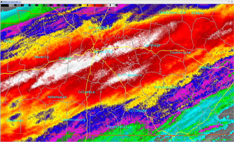
Hazardous Weather Outlook
NWS’ most recent weather outlook:
Sunday
Showers will be ending this morning from west to east. However, given the very high rainfall amounts that fell overnight, area creek and stream levels will likely be rising through the day. Stay alert as additional river flood warnings may need to be issued for your area.
Monday through Saturday
Stream and creek levels will remain elevated into mid week. River flood warnings and/or advisories may be posted for your area. Otherwise, it will be turning colder toward the end of this work week. Low temperatures will fall to near freezing for many areas by both Thursday and Friday mornings. Stay tuned as possible frost and/or freeze warnings may be issued later this week.


