
A Winter Storm Warning is in effect now through 6am Tuesday, reports National Weather Service (NWS).
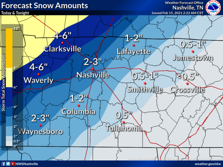
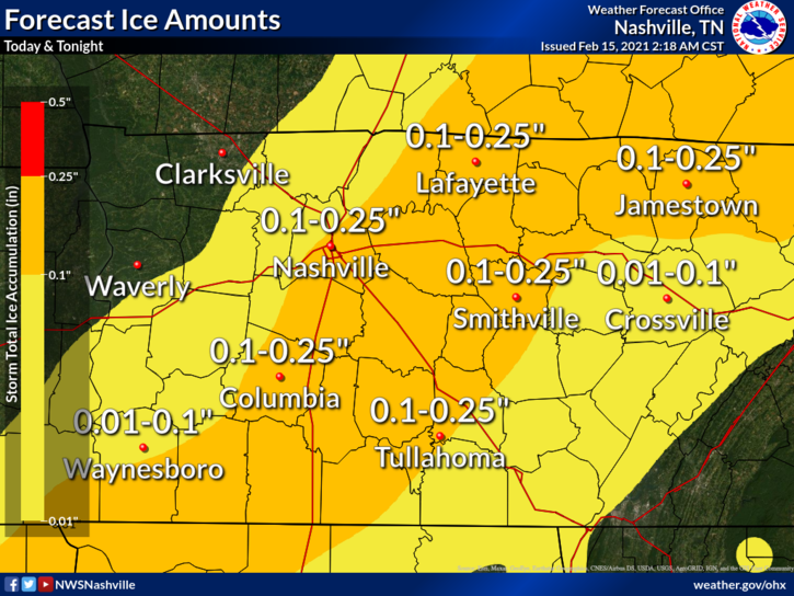
NWS projects heavy mixed precipitation, with somewhere between 1-3 inches of snow for the Williamson County area and .01-.25 inches of ice.
*These totals could still go up or down due to some forecast uncertainty, but regardless travel will become very hazardous through at least Tuesday, explains NWS. The high end of these ranges are the highest possible amounts.
Additional Forecast Details from NWS:
- Precipitation will start as mainly freezing rain Sunday night with ice accumulation making travel hazardous.
- On Monday, the precipitation will change over to all snow. Most of the snow accumulation will occur in the late afternoon and evening hours of Monday.
- Very cold air following the storm will make travel conditions slow to improve through
Tuesday.
Precautionary/Preparedness Actions:
- If you must travel, keep an extra flashlight, food, and water in your vehicle in case of an emergency.
- Slow down and use caution while traveling.
- The latest road conditions for the state you are calling from can be obtained by calling 511
Daily Forecast – Updated Sunday, Feb 14 4:00pm
Sunday
A slight chance of snow and sleet before 4pm, then a chance of freezing rain and sleet. Cloudy, with a high near 29. North wind around 10 mph. Chance of precipitation is 30%. Little or no snow and sleet accumulation expected.
Sunday night: Freezing rain and sleet, mainly before 5am. Low around 24. North wind around 10 mph. Chance of precipitation is 100%. New ice accumulation of around a 0.1 of an inch possible. Little or no sleet accumulation expected.
Monday
Freezing rain and sleet before noon, then snow. High near 27. North wind around 10 mph. Chance of precipitation is 100%. New ice accumulation of less than a 0.1 of an inch possible. New snow and sleet accumulation of 2 to 4 inches possible.
Monday Night: Snow, mainly before midnight. Low around 15. West northwest wind 5 to 10 mph. Chance of precipitation is 80%
Tuesday
A chance of flurries before noon. Mostly cloudy, with a high near 23. West northwest wind around 5 mph.
Tuesday Night: Mostly cloudy, with a low around 13. North wind around 5 mph becoming east northeast after midnight.


