
1 | 2 | 3 | 4 | 5 |
3. Eagleville Ride
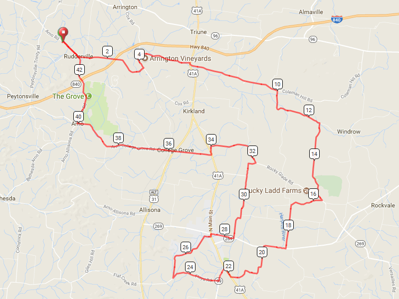
This ride takes you through the southeastern part of the county, mostly rolling hills and wide scenic views. It starts and ends at Page High School.
It is 43.1 miles long and goes up 1,782 feet and down 1,779.
Map
Elevation Change

Route Instructions
| Leg | Dir | Type | Notes | Total |
| → | Right | Turn right onto Arno Rd | 0.0 | |
| 0.8 | ← | Left | Turn left onto McDaniel Rd | 0.8 |
| 2.8 | ← | Left | Turn left onto Cox Rd | 3.7 |
| 0.6 | → | Right | Turn right onto Patton Rd | 4.3 |
| 2.0 | → | Right | Turn right onto US-31 ALT S/US-41A S | 6.3 |
| 0.1 | ← | Left | Turn left onto Patterson Rd | 6.4 |
| 3.6 | → | Right | Turn right to stay on Patterson Rd | 10.0 |
| 2.5 | → | Right | Turn right | 12.5 |
| 0.7 | ↑ | Straight | Continue onto Morgan Rd | 13.2 |
| 2.2 | ← | Left | Turn left onto Rocky Glade Rd | 15.4 |
| 0.3 | → | Right | Turn right onto Little Rock Rd | 15.7 |
| 1.3 | ← | Left | Turn left onto North Ln | 16.9 |
| 1.7 | → | Right | Turn right onto TN-269 W/TN-99 W | 18.6 |
| 0.9 | ← | Left | Turn left onto Mt Vernon Rd N | 19.5 |
| 2.3 | → | Right | Turn right onto US-41A N | 21.8 |
| 0.4 | ← | Left | Turn left onto TN-99 W | 22.3 |
| 0.6 | → | Right | Turn right onto Floyd Rd | 22.8 |
| 1.9 | → | Right | Sharp right onto Cheatham Springs Rd | 24.7 |
| 1.5 | ← | Left | Keep left to stay on Cheatham Springs Rd | 26.2 |
| 1.1 | ← | Left | Turn left onto S Main St | 27.4 |
| 0.1 | → | Right | Turn right onto Old Hwy 99 | 27.5 |
| 0.8 | ← | Left | Turn left onto TN-269 E/TN-99 E | 28.3 |
| 0.2 | ← | Left | Turn left onto Swamp Rd | 28.4 |
| 1.0 | ↑ | Straight | Continue onto Shoemaker Rd | 29.4 |
| 1.6 | ↑ | Straight | Continue onto Rocky Glade Rd | 31.0 |
| 0.8 | ← | Left | Turn left onto John Windrow Rd | 31.8 |
| 2.2 | ← | Left | Turn left onto Covington Rd | 34.0 |
| 0.2 | ← | Left | Turn left onto US-41A S | 34.2 |
| 0.1 | → | Right | Turn right onto College Grove Rd | 34.3 |
| 0.7 | ↑ | Straight | Continue onto Bellenfant Rd | 35.0 |
| 0.8 | ← | Left | Turn left onto US-31 ALT S | 35.8 |
| 0.0 | → | Right | Turn right onto Arno-College Grove Rd | 35.8 |
| 4.2 | → | Right | Turn right onto Arno Rd | 40.0 |
| 3.6 | ← | Left | Turn left toward Arno Rd | 43.6 |
| 0.0 | → | Right | Turn right onto Arno Rd | 43.6 |
Full interactive map and details.


