
National Weather Service (NWS) reports we will have great weather for the Fourth of July weekend.
NWS FORECAST SUMMARY
• Dry, cooler and less humidity for the next couple of days
• Heat returns Sunday but rain chances hold off until mid-week
NWS FORECAST DISCUSSION
Despite the majority of the shower activity exiting our southern counties as we speak, the frontal boundary we are waiting on is just now moving into our northwestern counties. This boundary will continue to sag southeastward throughout the day, ushering in clear skies and cooler temps for all. Looking at some of our latest satellite observations, looks like a decent bit of fog has developed across our northwest and may continue to sag southward
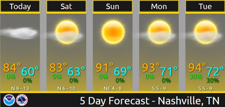
as skies clear and winds calm down. Today probably won’t seem like July to most, as highs will only reach the low to mid 80s. Expect for dew points to drop through the day as the frontal boundary pushes through. Things will be semi-chilly the next few nights, with overnight lows dropping into the upper 50s to low 60s.
This weekend looks nothing short of fantastic for a holiday weekend. High pressure will take a strong hold over the eastern half of the U.S., ushering in a drier weather pattern through the weekend and possibly into the first few days of next week. Temps will remain well-below normal on Saturday with highs for much of the area in the upper 70s to low 80s. This much cooler weather will be short lived though, as summertime temps will return on Sunday with highs back in the upper 80s to low 90s.
Despite the warmer temps on Sunday, dew point temps will still be fairly manageable. Temps will remain the same heading into the first half of next week, although moisture will begin to return to the area making that summertime mugginess return. Should make it through Monday and possibly Tuesday with mostly dry weather, but could see some afternoon showers/t`storms develop. Middle of next week into next weekend is a little uncertain at this point. Looks like a strong upper-level ridge will begin to develop over the western half of the U.S. with a weak trough developing across the east. This would spell additional moisture to the area and the return of showers and t`storms to the forecast. The other point of contention will be the eventual path of T.S. Elsa. Not looking like Middle TN will see any impacts from this storm, but depending on its` proximity could alter our forecast by the end of next week. Regardless, temps look to hover right around seasonal normals, with highs in the upper 80s to low 90s and overnight lows in the upper 60s to low 70s.
WEEKEND TEMPS
Friday
Partly sunny, high near 84, low around 59
Saturday
Sunny, high near 82 low around 61
Sunday – Fourth of July
Sunny, High near 89, Low around 67


