
1 | 2 | 3 | 4 | 5 |
2. Wellness Ride
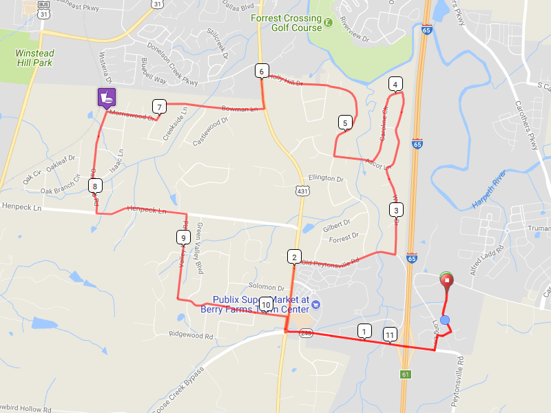
This ride is the shortest one on the list, but it still takes you through some scenic views south and west of Franklin. It is funny how different even familiar areas look when you pass them at riding rather than driving speed. It starts and ends at the county Ag-Expo Center.
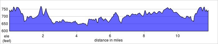
It is 11.8 miles long and goes up 572 feet and down 526 feet.
Map
Elevation Change
Route Instructions
| Leg | Dir | Type | Notes | Total |
| ← | Left | Turn left | 0.1 | |
| 0.2 | → | Right | Turn right toward Long Ln | 0.3 |
| 0.1 | ← | Left | Turn left onto Long Ln | 0.4 |
| 0.1 | → | Right | Turn right onto Peytonsville Rd | 0.5 |
| 0.3 | ↑ | Straight | Continue onto Goose Creek Bypass | 0.8 |
| 0.8 | → | Right | Turn right onto US-431 N | 1.5 |
| 0.5 | → | Right | Turn right onto Old Peytonsville Rd | 2.0 |
| 0.7 | ← | Left | Turn left onto Warrior Dr | 2.8 |
| 0.6 | → | Right | Turn right onto Ascot Ln | 3.4 |
| 0.6 | ← | Left | Turn left onto Caroline Cir | 4.0 |
| 0.6 | → | Right | Turn right onto Ascot Ln | 4.5 |
| 0.3 | → | Right | Turn right onto Holly Hill Dr | 4.8 |
| 1.2 | ← | Left | Turn left onto US-431 S/Lewisburg Pike | 6.0 |
| 0.2 | → | Right | Turn right onto Bowman Ln | 6.2 |
| 0.7 | ← | Left | Turn left onto Springdale Dr | 6.9 |
| 0.1 | → | Right | Turn right onto Morriswood Dr | 7.0 |
| 0.4 | ← | Left | Turn left onto Oakwood Rd | 7.4 |
| 0.7 | ← | Left | Turn left onto Henpeck Ln | 8.1 |
| 0.6 | → | Right | Turn right onto Valley Ridge Rd | 8.8 |
| 0.6 | ← | Left | Valley Ridge Rd turns slightly left and becomes Moss Ln | 9.4 |
| 0.8 | → | Right | Turn right onto US-431 S | 10.2 |
| 0.1 | ← | Left | Turn left onto TN-248 N/Goose Creek Bypass | 10.3 |
| 0.9 | ↑ | Straight | Continue onto Peytonsville Rd | 11.2 |
| 0.1 | ← | Left | Turn left onto Long Ln W | 11.3 |
| 0.1 | → | Right | Turn right | 11.4 |
| 0.1 | ← | Left | Turn left | 11.5 |
| 0.2 | → | Right | Turn right | 11.7 |
Full interactive map and details.


